


Humphreys Voting District, Sullivan County, Missouri
About
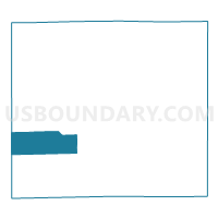
Outline

Summary
| Unique Area Identifier | 611442 |
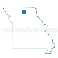
| Name | Humphreys Voting District |
| County | Sullivan County |
| State | Missouri |
| Area (square miles) | 26.01 |
| Land Area (square miles) | 25.76 |
| Water Area (square miles) | 0.25 |
| % of Land Area | 99.04 |
| % of Water Area | 0.96 |
| Latitude of the Internal Point | 40.13935440 |
| Longtitude of the Internal Point | -93.28518170 |
Maps

Graphs
Select a template below for downloading or customizing gragh for Humphreys Voting District, Sullivan County, Missouri


Neighbors
Neighoring Voting District (by Name) Neighboring Voting District on the Map
- Liberty Voting District, Grundy County, MO
- Marion Voting District, Grundy County, MO
- Osgood Voting District, Sullivan County, MO
- Reger Voting District, Sullivan County, MO
- Taylor Voting District, Sullivan County, MO
- West Polk Voting District, Sullivan County, MO
Top 10 Neighboring County Subdivision (by Population) Neighboring County Subdivision on the Map
- Polk township, Sullivan County, MO (2,910)
- Liberty township, Grundy County, MO (436)
- Bowman township, Sullivan County, MO (395)
- Duncan township, Sullivan County, MO (385)
- Marion township, Grundy County, MO (248)
- Taylor township, Sullivan County, MO (98)